
Discover and feel every breath of heaven and earth and experience many new things when participating in the most beautiful trekking routes of Vietnam in 2022 that possess attractive beauty and are full of dangers that anyone wants to conquer once.
Trekking (hiking) has long been a popular tourist activity. The trekkers are always ready to hit the road with a persistent spirit, brutal physical strength, excellent wilderness survival skills, and especially infinite love for nature. Let’s explore the beautiful and challenging trails on the list of must-visit places once in a lifetime with trekking enthusiasts.
Trekking is an exciting experience chosen by a large number of young people to participate. In Vietnam, trekking routes always have a unique attraction for many people. Let’s conquer five trekking routes in Vietnam possessing attractive beauty but also full of dangers that anyone wants to conquer once.
Contents
- Ta Nang – Phan Dung: The most beautiful trekking route in Vietnam!
- Bidoup Peak: Trekking Route for Beginners!
- Lung Cung: The favorite 2022 trekking destination of backpackers!
- Trekking Lao Than Peak: The ideal place to hunt clouds!
- Fansipan Peak: Dangerous trekking route!
- Ba Den Mountain: Trekking place near Ho Chi Minh City
- Cat Ba National Park: Trekking place near Hanoi
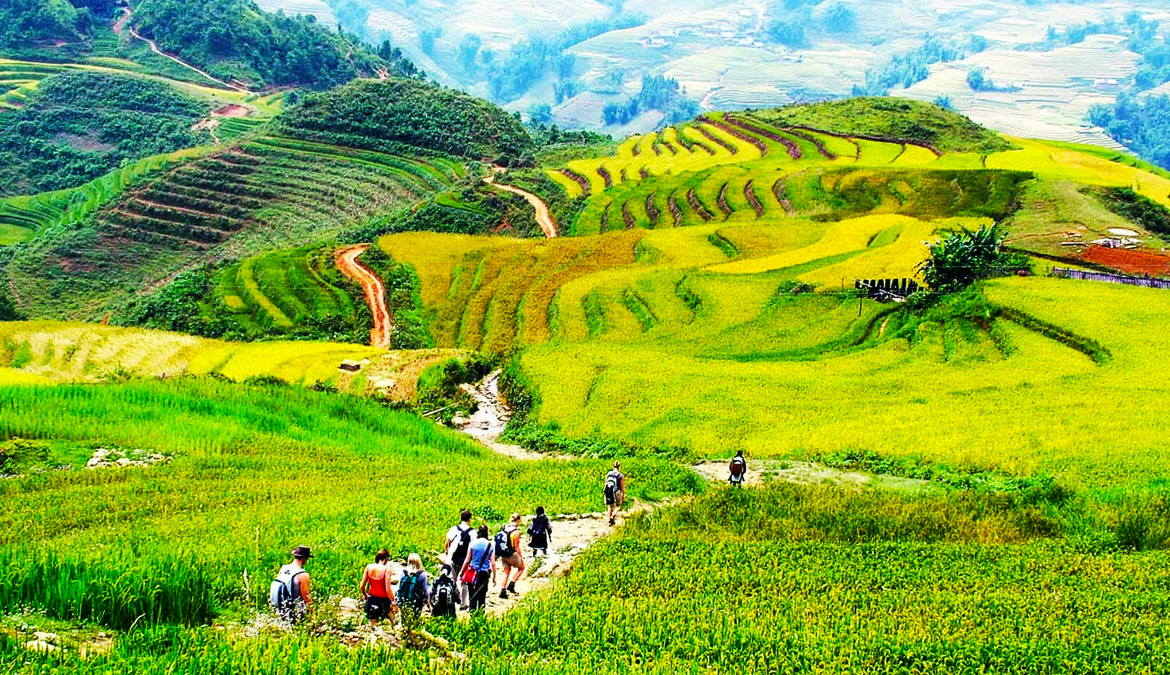
Ta Nang – Phan Dung: The most beautiful trekking route in Vietnam!
With more than 50 km, Ta Nang – Phan Dung road passes through 3 provinces of Lam Dong, Ninh Thuan, and Binh Thuan. This route is one of the most beautiful trekking routes in Vietnam.
Those who discover this road have to cross the forest, climb the pass, and cross the stream, moving from an altitude of 1,100 m down to 500 m above sea level. This area is a transitional land from the plateau to the central coast.

Typically, Ta Nang – Phan Dung trekking has two paths. The road following the high hill trail out of the forest takes about two days and one night. This route is relatively easy to go but has many turns. The road to the waterfall and then out to the forest takes three days and two nights. This path is also the most dangerous, especially in the rainy season.
Describing the wild beauty of Ta Nang mountain, the moment walking under the first rays of the new day, when the mist is still wandering on the hillside, will make you feel like you are in paradise on earth. Amidst the deep mountains and forests, everything seems to be slowing down. Surrounded by only trees, flowers, birds chirping, the scene is entirely separate from the noisy and bustling life outside.

This route is also ideal for those passionate about trekking who want to find a peaceful place, immerse themselves in nature. However, it would be best to go in 10 or more people, with local help. Ta Nang at night is also an ideal place for photography enthusiasts to take pictures of the galaxy.
However, with rugged mountains, conquering this route is not easy for many people, especially in the rainy season. With vast forests and dangerous rocky terrain, Ta Nang – Phan Dung causes many difficulties for those who want to conquer.
This place has witnessed many accidents and incidents that have killed those who want to conquer. Therefore, if you’re going to beat Ta Nang – Phan Dung, you need to be fully equipped with the knowledge and choose the right time.
Bidoup Peak: Trekking Route for Beginners!
During the journey to discover Lang Biang plateau – Nui Ba, Lam Dong, do not forget to conquer Bidoup – the mountain peak is considered the “roof” of the Central Highlands. Explore the flora, discover the red maple leaf season Bidoup route, the beauty of nature.

Have you ever thought that you will be awakened by the sound of wild birds in the early morning or see squirrels, wild boars, wild chickens running around looking for food? If not, this trekking trip to the top of Bidoup mountain, considered the highest in Lam Vien plateau with an altitude of 2,287m, will be an excellent choice for you.

The journey begins through the canopy of pine forests, through rivers and streams where the Da Nhim River originates, connecting Lam Dong with Ninh Thuan, and to the ancient forest with a unique and diverse ecosystem. Rare flora and fauna such as Golden-throated Sparrow, Gibbon, Douc, Vampire Frog, Mi Langbiang, Po Mu tree over 1,300 years old, Langbiang rhododendron, and many species of orchids, etc.
If you are a first-time climber with moderate health, you can choose the first-day journey from DT 723 to the campsite near the top of the mountain, the second day from the camp to the top of Bidoup mountain, down to the foot of the hill at Bidoup mountain. Glitter. The scenery on the journey to conquer is stunning. The pine hills, waterfalls, vegetation, etc., make you dispel fatigue.

Ta Lien Son is known as a “fairy forest” with poetic and beautiful landscape space. Vegetation, abundant and pristine creatures with ancient trees, red maple leaves falling every autumn, green moss carpets, etc., are images that will stay forever in your mind.

The process of conquering Ta Lien Son mountain is not tricky like other roads, but the fairy beauty of the sun streaks through the trees during the journey, the old forest, and the red maple leaves that make the place go crazy. This route is going to be a memorable trip.
You will no longer worry about the noisy, busy city when you reach the top of the mountain because you will be overwhelmed by the picture that appears before your eyes. The whole town looming through the clouds through the undulating mountain waves will be an image you will never forget.
Lung Cung: The favorite 2022 trekking destination of backpackers!
Contributing to the next trekking destination that many backpackers love is Lung Cung peak. It is about 20km from Mu Cang Chai town. And it has an altitude of 2,913m. To conquer Lung Cung, you need to pass 20km of mountainous, winding, narrow road with steep slopes.
However, once you reach the top, you will feel extremely excited. Standing on the top of the mountain, watching the ancient green forest, listening to the birdsong, the insects calling. Or inhaling the scent of the earth, the wind, the flowers will help you feel more peaceful. Take away some of the difficulties and hardships of the journey you have just gone through.
Located in Yen Bai, with an altitude of 2913m above sea level, Lung Cung is a year-round mountain peak covered with white clouds. That’s why Lung Cung peak always attracts adventurous young people to conquer.
To reach Lung Cung peak, visitors can only choose three directions from Thao Chua village, Lung Cung village, or Tu San village. Visitors will take about two days to cross the roads with ancient forests and dangerous cliffs. Reaching the top of Lung Cung, visitors seem to step into the intersection between heaven and earth and enjoy the majestic natural beauty.
Trekking Lao Than Peak: The ideal place to hunt clouds!
Location: Lao Than Mountain
Location: Phin Ho village, Y Ty commune, Bat Xat district, Lao Cai province.
Coordinates: 22.610420°, 103.686535°.
Altitude: 2,862m
Climbing time: 2 days one night
Outstanding Outdoor Activities: Trekking, Climbing, Camping
Ideal time: September – February
If you are looking for a place where you can fully experience the combination of trekking, camping, cloud hunting, BBQ but have too much time and health, then Trekking Lao Than – cloud hunting Y Ty is The best choice for you.

If Fansipan is the roof of Indochina, Lao Than is known as the roof of Y Ty. Mount Lao Than belongs to Y Ty commune, Bat Xat district, Lao Cai. The mountain has an altitude of 2800m. It is a trekking destination suitable for mountain climbing and cloud hunting in 2 days and one night (2N1D). However, to conquer successfully, you should remember to ask the people in the village to guide you. At the same time, bring enough dry food for the journey.
Dubbed the most beautiful cloud hunting spot in Lao Cai, Lao Than mountain is chosen by many backpackers to conquer. The road to conquer this mountain is not complicated, and only when approaching the top will there be a slope. However, with the characteristics of hot weather, strong wind, and nature with many shrubs, this route also causes many difficulties for conquerors.
In particular, the trail to the top of Lao Than has many turns that can make backpackers get lost. Therefore, hiring indigenous people to guide the way is extremely necessary to conquer this mountain. The ideal time to hunt clouds in Y Ty – Trekking Lao Than falls from the end of September to February every year because it often has light rain, so it is easy to gather clouds.
During this time, you should see how the weather in the next ten days in Lao Than will be like to have the best climbing plan and itinerary. For those who like to hunt clouds, you can go on windy, sometimes cold days. At this time, the clouds will be more floating and more accessible to track than other days.
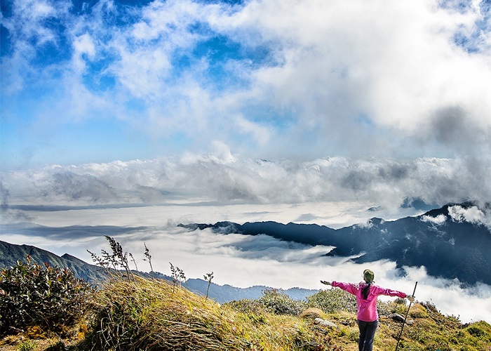
Fansipan Peak: Dangerous trekking route!
As the highest mountain in Vietnam, conquering Fansipan is the goal of many backpackers. Owning an altitude of 3100m, Fansipan is covered with clouds all year round, bringing poetic scenery. Usually, with the traditional trekking route, visitors will take about 2 to 4 days to conquer.

Doc Mit to the top of Fansipan is the most dangerous and difficult road, so it is usually only chosen by professional climbers. Due to the terrain being mainly narrow cliffs, slippery cliffs, steep slopes, this trekking route always causes many difficulties for even experienced climbers.
Not only the highest in Vietnam, but Fansipan is also the highest mountain in Indochina, conquered by backpackers. With an altitude of more than 3,100 m, you can beat this mountain on many roads.

The easiest way is to start from Tram Ton to the top and go back along this road, lasting 2-3 days. The second time lasts about four days with a distance of approximately 19.5 km, starting from the “back” of the Hoang Lien range. Also beginning from Tram Ton, but the way back follows Muong Hoa valley, Cat Cat stream, goes along the east slope of Hoang Lien range.
If you explore the “traditional” way, it takes you 2-4 days to move without using the cable car. The route from Doc Mit, Binh Lu to the top is challenging, this is a dangerous journey, and only professional mountaineers with complete equipment should experience it.
That area is mainly craggy cliffs. The path is extremely narrow, the cliffs are steep and slippery, besides there are many snakes, so you need to think before choosing to explore this path.
Ba Den Mountain: Trekking place near Ho Chi Minh City
Considered the roof of the Southeast, Ba Den Mountain is a trekking route that many young people love. From the foot of the mountain to Dien Ba (the connection point in the middle of the hill), visitors can choose from 3 options to reach the top: cable car, slide or walking.
It is about 986m high and is known as the highest mountain in the Southeast region. Ba Den Mountain always attracts a large number of backpackers to conquer at weekends. This mountain is nearly 100km from the center of Ho Chi Minh City, so that you can go back and forth during the day.
Seen from a distance, Ba Den Mountain stands tall like a conical hat in the middle of the plain. Half like a challenge. Half as attractive to those who love to move and love to explore. The higher you go, the cooler the mountain air. When you reach the top of the mountain, you will be delighted to admire the view of wild but poetic land. Also, listen to the thrilling legendary story.
However, visitors can only follow the trail behind Dien Ba to conquer the top of the mountain from here. With complex and equally dangerous terrain with many caves and large rocks, visitors will always have to be careful with avalanches and poisonous snakes lurking during the journey.
Beautiful trekking routes always attract many young people to conquer. However, with the above trekking routes, be careful. There are always dangers that hinder your journey.
Cat Ba National Park: Trekking place near Hanoi
Coming to Cat Ba tourism, you will experience various activities, from the sea to the forest. Cat Ba Island – where the sea and forest meet to form an affluent natural population with rare flora and fauna.

Trekking activities through Cat Ba National Park, Hai Phong attract domestic and foreign tourists when coming to Cat Ba. Cat Ba National Park is 60 km from the city center on Cat Ba island, Cat Hai district. This is a trekking spot not to be missed for young people who are passionate about exploring.

You can choose the right time to trek Cat Ba National Park from April to October. At this time, you can fully experience climbing activities or explore diverse ecosystems. Spreading over 15200 hectares, Cat Ba National Park is ideal for developing many animals and plants.
UNESCO has recognized cat Ba National Park as a biosphere reserve of the world. You can see countless characteristic limestone forests, caves, streams, waterfalls following the water flowing to the sea. .
In addition, Cat Ba National Park is also attracted by the values of human history. Archaeological remains have been found that show that humans may have lived in this land from 6000 to 7000 years ago, it is worth exploring.
For outdoor enthusiasts, it will be no stranger to trekking – exploring the roads with your own feet. You will feel every breath of heaven and earth on the trekking journey and experience many new things. Above is the introduction to you the most beautiful trekking in Vietnam that many of you will be tempted to take your feet to explore.


