

Contents
- 01. The geographical location of Kon Ka Kinh National Park – Vietnam Travel
- 02. Hydrology
- 03. Traffic
- 04. Population
- 05. The value of Kon Ka Kinh National Park
- 06. Landscapes in Kon Ka Kinh National Park
- 07. Experience your Vietnam Travel trip at Kon Ka Kinh National Park
- 08. Additional information
- Vietnam Travel- Travel like locals
01. The geographical location of Kon Ka Kinh National Park – Vietnam Travel
Overview of Kon Ka Kinh National Park
Vietnam Travel – Kon Ka Kinh National Park is located between the East and the West of the Truong Son Range in the three districts Mang Yang, Kbang, and Dak Doa of Gia Lai Province. The administrative center of the park is in Ayun commune, Mang Yang district, about 50 km northeast of Pleiku city. Traveling to Vietnam, you should go to this national park to experience majestic nature.

Area
The total natural area of Kon Ka Kinh National Park is 41,780 ha.
Terrain
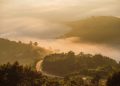
Kon Ka Kinh National Park (Gia Lai) has the distribution in the area adjacent to the Pleiku plateau with the Kon Ha Nung plateau, including many mountain ranges with an average elevation of 1,200 – 1,500 m, the highest being Kon Ka Kinh peak of 1,748 m, the lowest in the eastern land with the height of about 600 m.
The topography of Kon Ka Kinh National Park is lower from north to south. The east side has significant slopes but is short, about 800 – 1,700 m high. Kon Ka Kinh mountain is lower from the East to the West with long and relaxed slopes. The separation of the terrain is not complicated, and the altitude ranges from about 900 – 1,500 m.

Climate
The tropical monsoon highland regime influences Kon Ka Kinh. Each year has two distinct seasons; the rainy season lasts from May to November, the dry season lasts from December to April next year.
The average annual temperature is from 21°C to 25° C. In which May has the highest average temperature of 25 °C. In contrast, January has the lowest average temperature of 16 ° C. The Kon Ka Kinh peak has a temperature below 15 ° C.
The average total annual rainfall varies from 2,000 – 2,500 mm. In particular, rainfall concentrates from May to November, accounting for 70-75% of the yearly rainfall.
The annual average humidity is 80%. The prevailing wind direction is the southwest monsoon blowing in the dry months and the northeast monsoon blowing in the rainy months.
So with this climate, Vietnam Travel recommends you travel to this park from February to April to have the best Vietnam Travel trip.
02. Hydrology
Kon Ka Kinh National Park has a system of 3 main streams belonging to the headwaters of the rivers in the region. In which there are many small stream branches, which are relatively dense density, evenly distributed. The features of the stream system here are in the rainy season, having a large amount of water, whereas, in the dry season, it is shallow.
Ba river’s drainage basin:
It is the most extensive river system in the park originating from stream branches in the north of Dak Roong commune, flowing from the north to the south, flowing through the National Park in Sub-area 18 with a length of about 11 km. All stream systems on the northeastern and southeastern sides of Kon Ka Kinh belong to the basin of the Ba River, with an area of about 230 km². The average flow module of the whole bay reaches 22.2 l / s / km²; the upstream sector has an annual average high flow of 40 – 50 l / s / km². The coefficient of basin flows averages 0.41.
Dak Pne River’s drainage basin
It originates from many streams in the western slope of the Kon Ka Kinh range of Kon Pne commune, with 144 km². The Dak Pne River flows from the north, merges with the Dak Bla River in Kon Plong District. Then it flows through Kon Tum City, combined with the Po Ko River, providing water for Yaly and Se San III Hydroelectric power stations.
A Yun River’s drainage basin
This basin originates from the southern slope of the Kon Ka Kinh mountain range, with a total area of 60 km².
03. Traffic
Most of the buffer zone communes of Kon Ka Kinh National Park have inter-village and inter-commune roads. However, only Mang Yang district has well-invested road infrastructure, so transportation is relatively convenient. In the buffer zone communes, most inter-commune roads are soil roads, so it is challenging to travel in the rainy season. In particular, Kon Pne is the most remote buffer zone commune. From the center of the Kbang district to the center of the municipality, it has more than 80 km of soil roads and more than 10 km of very rugged mountain passes. So that in the rainy season, it is almost impossible to walk.
04. Population
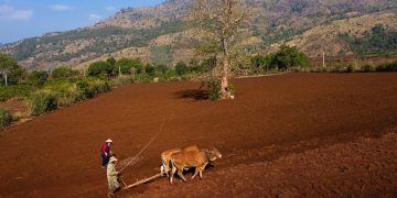
The buffer zone population is 80% ethnic minorities, of which the majority are Ba Na people who have long lived in the K’Bang and Dak Doa districts. There are also nine other ethnic minority communities, such as Tay, Nung, Hmong, Dao, etc., who migrated from the Northern provinces after 1975 but accounted for a tiny percentage of the region’s total population. These communities are scattered in A Yun and Kroong communes. The Kinh ethnic group mainly lives in the Mang Yang district, accounting for 30-40%. Most of the King people in the north and the Central region provinces migrated here to live and settle down.
Bana community
Ba Na is the most populous ethnic minority in the Kon Ka Kinh and Central Highlands, with a population of over 200,000 (2009). Their language belongs to the Khmer group. As long-lived indigenous people, they have created a unique culture here.
Culture
The long-standing cultural feature of the Ba Na ethnic group is gong culture. The festivals such as fighting buffalo, grave leaving, weddings are highly community. They play the gongs, then sing and dance together during the Tet holidays, in the sowing seasons, and at the end of the harvest season. In recent years, the Chinese New Year has also become very familiar to them.
The Ba Na people live on the stilt house. In the middle of the village, there is a tall and beautiful communal house with two roofs, which is the village’s headquarters. It is the place where the village elders meet to discuss work, the meeting of the villagers, where the unmarried boys spend the night, where holds the ceremonies of the community custom. It is also a place where to welcome strangers to the village.
Matriarchal affected society
Customs and practices here are matriarchal affected societies. Women are more valuable in the family in which the children bear the mother’s surname. But women are also the ones who have to work the hardest in daily tasks. Men only do things like cutting trees, making houses, working on fields, knitting, hunting wild animals, etc.
The disintegrated matriarchy has increased the status of men. However, the matriarchal influence is still evident in family, clan, and marriage relations. The mother’s side is closer than the father’s. Monogamous marriage is a fundamental principle in family building. The after-marriage rotation of living place is very common. At the end of the cycle (with the wife’s family and then with the husband), the couple moves independently to create a new family home.
Traditonal folk songs
Ba Na folk songs are plentiful, including epic songs, lullabies, and sacrificial songs. These folk songs have literary and musical merit and historical, social, and national significance. Ba Na musical instruments are diverse, including different structural gong sets, T’rung, krong pút, kơ ni, frame, gong, arong, etc.
Among Ba Na folk dances, ritual dances and performing at festivals are popular. Ba Na folk songs and tales are unique literary works with great value.
The cultivation method of the Ba Na people is mainly shifting cultivation. From the beginning of the twentieth century, they learned how to make wet rice; however, the area and productivity were minimal. They often raise poultry and cattle in every family, such as buffaloes, cows, goats, pigs, and chickens. Handicrafts such as knitting, weaving, pottery, and forging have not yet been wide-popular.
05. The value of Kon Ka Kinh National Park
Biodiversity and conservation
Kon Ka Kinh National Park has a very high biodiversity value with many distinct and intact forest ecosystems, especially with 2,000 ha of mixed forest between broadleaf and coniferous trees, with rare and precious species such as Vietnam hinoki, technical sitan, Carya Sinensis, nageia fleuryi, etc. This forest is the only special-use one in Vietnam with mixed types.
The flora is very diverse and vibrant, with 1,022 vascular plant species, up to 22 species listed in the Vietnam Red Book in 2007 and the World Red Book in 2010.
The forest fauna of the National Park is also very diverse, with 556 species, including up to 16 endemic species, 47 species named in the Vietnam Red Book in 2007, and the World Red Book in 2010.
With a diverse and rich flora and fauna system and unique ecosystems, Kon Ka Kinh National Park is the place to preserve the ecosystem standard sample and an invaluable repository for rare and precious species of flora and fauna in the Central Highlands.

The ecological environment in Kon Ka Kinh National Park
Not only known as a priority area for biodiversity conservation, but Kon Ka Kinh National Park plays a vital role in protecting the watershed of significant rivers, namely Ba River, Dak Pne River, and A Yun River. It provides irrigation water for thousands of hectares of coffee, pepper, agricultural land, and domestic water to Gia Lai and Kon Tum provinces districts.
Not only that, but Kon Ka Kinh forest contributes to climate control, flood prevention, soil erosion limitation, and maintenance of ecological balance for the whole region.
Besides, the Kon Ka Kinh forest supplies and regulates water sources for irrigation dams and hydroelectricity basins. For example, there is Hinh river hydroelectric lake, Dong Cam irrigation dam (Phu Yen province). Also, Yaly hydroelectric lake, Se San III power station lake (Gia Lai province).
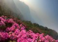
06. Landscapes in Kon Ka Kinh National Park
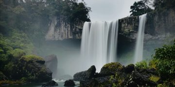
There are many attractions in Kon Ka Kinh National Park, such as the system of rivers, streams, falls, beautiful natural rapids. For instance, the Three-story waterfall, Nang Tien waterfall, Stone waterfall, La Ba river, H’Ngoi waterfall, 95 Waterfall, etc.

Among the attractions, the 95 Waterfall is the most famous and beautiful one with a height of about 40 m. From a distance, 95 Waterfall looks like a white ribbon hanging around to the melodies on a resounding green forest theme. In summer, the lukewarm water of the waterfall makes the air always cool.
In addition to the system of beautiful rapids, visitors have the opportunity to see firsthand the immense primeval forests, giant trees, and many rare and precious wildlife such as Asian black bears, mountain goats, roe deer, wild birds, etc.

07. Experience your Vietnam Travel trip at Kon Ka Kinh National Park
Indeed, Kon Ka King National Park has many advantages for tourism development. There are many majestic high mountains, a beautiful system of natural rapids, diverse flora and fauna, comfortable climate, fresh air, pleasant region high mountain. Therefore, Kon Ka Kinh is an attractive eco-tourism site for tourists from near and far.
Kon Ka Kinh National Park tours and attractions:
- Trip to visit Three-storey Waterfall: You will have the opportunity to admire the natural beauty, closed mixed forest of the broadleaf and coniferous forest. You can especially see the great pine tree.

- White Rock Mountain Sightseeing Tour: A place with standard specimens of typical forest ecosystems, rare animals, and a giant white stone block of about 100 m2.

- Sightseeing Botanical Garden and Wildlife Rescue and Development Zone: In these two areas, you can see a collection of Kon Ka Kinh flora and fauna.
- Discovery trip to the Kon Ka Kinh Peak: With an altitude of 1,748 m, after climbing up to the top, you can feel all the majesty of the Truong Son mountains. Besides, you can see firsthand the immense primeval forests with many rare and precious plant species of enormous size and shape. If lucky, visitors can see the douc langurs, hear gibbon singing, birds singing, and many wild animals in Kon Ka Kinh.

- Tour to learn the cultural identity of Ba Na ethnic group in Kroong & Kon Pne communes: You will have the opportunity to immerse in the atmosphere of festivals such as the festival of grave leaving, the celebration of gongs, wedding ceremonies, buffalo-fighting, etc.
- Relaxing Trip in the Administrative Service Area: With fresh air, calm and close to the natural landscape, Kon Ka Kinh National Park is very suitable for a weekend holiday.
08. Additional information
About 70 km from Pleiku city
The time to go from the city to the Park is 1h30p.
You can hire a guide 400,000-500,000 VND / 2 days
Overnight stay 200,000-300,000 VND
Above is all information about the Kon Ka Kinh National Park that is necessary to prepare a perfect Vietnam Travel trip if you choose this as a destination. We hope this is helpful, have a wonderful Vietnam Travel trip!


