Mang Den, a small town in Kon Plong district, Kon Tum province, is a perfect destination for tourists who love exploring nature and chasing clouds. With an average...
Read more
Mang Den, a small town in Kon Plong district, Kon Tum province, is a perfect destination for tourists who love exploring nature and chasing clouds. With an average...
Read more
Hunting clouds in Mang Den is an experience that backpackers often whisper to each other and must try once when traveling in Kon Tum mountain country. The feeling...
Read more
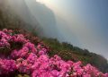
Not as majestic as the terraced fields in the Northwest, Mang Ri terraced fields have a beautiful appearance of the highland land, both peaceful and straightforward but also...
Read more
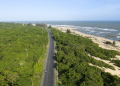
On the peaceful Dak Bla River, Kon Tum is a tourist destination looking for wild, majestic beauty. In addition to charming scenery, Kon Tum also contains in itself the...
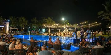
Read moreThe vibrant coastal lifestyle scene of Da Nang and Hoi An has just gained an exciting new player. Royal Capital...
Read more


© 2021 JNews - Premium WordPress news & magazine theme by Jegtheme.