
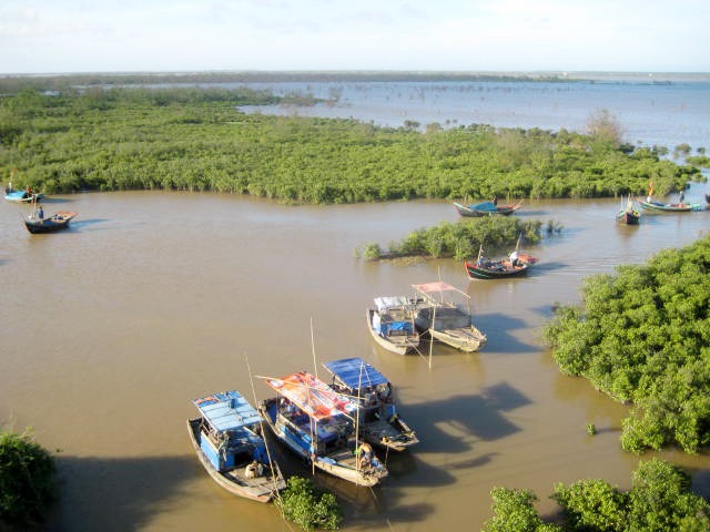
Xuan Thuy is a tidal wetland at the mouth of the Red River, where mudflats, mangroves, channels, lagoons and sandy islands meet the sea. A July 2025 Nhan Dan report places the park in present-day Ninh Binh Province; older sources use Nam Dinh, its former provincial setting.[5] It is a very different proposition from a conventional northern Vietnam sightseeing stop. The point is not to collect a guaranteed list of birds. It is to understand why this coastal landscape matters, travel lightly, and leave room for the tide, weather and wildlife to set the pace.
The site is internationally important. The Ramsar Sites Information Service records Xuan Thuy Natural Wetland Reserve as site 409, designated on 20 September 1988.[7] Its older administrative label, Nam Ha, is historical, not a present-day address. Vietnam’s tourism authority also reports that UNESCO recognised the area as a core zone of the Red River Delta Biosphere Reserve in 2004.[1] A 2024 Vietnam News Agency report likewise places it within the biosphere reserve.[2] These conservation designations explain the wetland’s importance; they do not guarantee that a particular bird will be present on a particular day.
Why late 2026 is a meaningful season
The clearest recurring seasonal evidence comes from the Vietnam National Authority of Tourism: between October and March, thousands of wild birds migrate from the north to Xuan Thuy.[1] That window makes late October, November, December and the first months of 2027 a reasonable period for a wildlife-focused visit. It does not mean that every week will have the same abundance, that every species will be visible, or that a 2026 count has already been recorded.
The distinction matters. The season is an annually recurring ecological pattern described in published sources. A “current sighting” would require a dated observation from the park, a conservation survey or a reliable observer. None is supplied here. The image above is older still: it is a 2008 landscape photograph, useful for showing mangrove and estuary scenery only. Treat late-2026 planning as a chance to observe habitat and natural rhythms, not as a promise of a spectacular flock.
Older conservation documentation describes the park as a staging and wintering area for migratory waterbirds. It records more than 20,000 waterbirds during surveys in 1988 and 1994, and an estimate of more than 33,000 shorebirds passing through in spring 1996.[3] Those figures establish the site’s historical ecological importance. They are not a baseline for 2026, and they should not be repeated as a live forecast.
The same source lists globally threatened or near-threatened species regularly recorded at the park, including Black-faced Spoonbill, Chinese Egret, Spotted Greenshank, Saunders’s Gull, Spoon-billed Sandpiper and Asian Dowitcher.[3] The 2024 VNA feature gives a more recent broad headline of more than 220 migratory and waterbird species recorded, including nine on the IUCN Red List.[2] “Recorded in the park” is the careful wording: it is not the same as saying all of those species will be present during your visit.
Read the landscape before looking for birds
The park’s value is tied to the meeting of land, river and tide. The conservation source describes three islands and intertidal mudflats at the Ba Lat mouth, with natural mangrove, sandy areas, coastal marsh and aquaculture ponds.[3] The mudflats are feeding habitat. Mangroves provide shelter and nursery functions, while channels and ponds create a mosaic rather than a single viewing point.
That geography changes how a visit should feel. A high tide can cover feeding flats that are exposed later. A quiet edge can be more valuable than a crowded “best spot”. Wind, haze and the low elevation of the delta also affect visibility. Even when a visitor sees fewer birds than hoped, the tidal system remains the subject. Look for how water moves through creeks, where mud is exposed, and how local livelihoods share space with protected habitat.
The VNA account mentions travelling along the Vop River toward the Ba Lat Estuary and visiting the islets of Con Ngan, Con Lu and Con Xanh.[2] Those are reported landscape options, not a current itinerary or a statement that every route operates daily. Before setting out, ask the park management or a locally established guide which areas are open, what the tide allows, and where visitors should not land or walk.
A practical late-2026 planning approach
Start with the date, then check the operating reality. Seasonal evidence supports the broad October–March window, but it does not establish transport timetables, boat departures, entrance fees, guide rates or accommodation availability for a future date. Confirm those details directly and close to travel. If no official channel publishes a detail, do not treat an old blog or a social-media post as a current promise.
Build the day around patience rather than a checklist. A pre-dawn departure may be attractive to birders, but do not assume it is permitted or available. Ask about the safest legal access point, tide timing, weather cancellation policy and whether binoculars can be used from an approved route. A guide with wetland knowledge can help identify distant birds without encouraging visitors to approach them. No responsible guide can guarantee a species list.
Bring binoculars if you have them, muted clothing, sun protection, water and footwear suited to damp ground. Keep equipment simple. Avoid drones, playback calls, loud music, flash and close approaches. Do not enter mudflats, mangrove stands or nesting areas just to improve a photograph. Never feed birds. If a guide suggests crossing a restricted area, ask why the rule exists and choose the lower-impact option.
The buffer zone is part of the story, not scenery to be treated as empty. Published descriptions note shrimp, fish, crab and clam livelihoods around the park.[1][2][3] Move carefully around working ponds, boats, paths and homes. Ask before photographing people or harvesting activity. Buy locally when appropriate, but do not turn a working wetland into a staged performance.
Conservation etiquette is part of the itinerary
Wetlands can look robust while being easily disturbed. Birds need undisturbed feeding and roosting areas; repeated approach can force them to spend energy flying instead of feeding. A quiet observer who stays on an approved route is doing more good than a visitor who gets a close photograph by pushing into the flock’s space.
The older conservation assessment also records pressures from aquaculture intensification, fishing and shellfish collection, as well as management choices that can alter mudflat and mangrove habitat.[3] Those findings are historical and should not be read as a current scorecard. They do explain why local rules and community livelihoods deserve attention. Follow current park instructions, avoid collecting anything, and leave no food or plastic behind.
Before agreeing to an outing, ask where the group will observe, whether that route is approved, and how it avoids disturbing feeding or roosting birds. Ask whether a boat is genuinely necessary or whether an authorised shore viewpoint meets your interests. Explain whether you are a beginner, a photographer or an experienced birder: a suitable pace and viewing distance matter more than the length of a species checklist. Confirm the meeting point and return arrangements before leaving a settled area.
For observation, let the habitat guide your expectations. Waders and other waterbirds use exposed intertidal ground to feed, while mangrove edges and channels provide different views of the same tidal system. A distant bird that stays undisturbed is a better encounter than a close bird that has been pushed from its feeding area. Use binoculars to keep a generous distance, note the time and general habitat, and avoid broadcasting an exact location if a sensitive roost is found. A simple field note can record tide, weather and habitat without pretending to be a formal survey.
The conservation record’s species list is useful for learning names before departure, but identification at a distance can be difficult. Do not turn a quick silhouette into a confident rarity claim. If you submit an observation to a birding group, include the date, approximate place, viewing conditions and a photograph only when it was made without disturbance. That practice keeps the difference between a personal observation and a verified monitoring record clear.
What to verify before you go
In the final days before travel, verify the park’s current administrative contact, access permission, opening arrangements, local transport and any boat or guide requirements. Check the tide and weather from a reliable current source. Ask whether sensitive areas are closed and whether photography rules have changed. If conditions are poor, keep the plan flexible rather than pressing into exposed mudflats or unsafe water.
If you are extending a northern wetland trip with the inland karst landscapes around Trang An, our Ninh Binh travel guide provides background on those places. Published on 22 March 2020, it describes the older, narrower Ninh Binh destination area, not the whole present-day province. Its fares, train times, administrative labels and operating details need fresh checks; do not use it as a current Xuan Thuy transport guide. Browse the North Vietnam stories archive for regional context, including its Red River Delta collection. Allow separately verified transfer time between coastal birdwatching and inland sightseeing rather than treating them as adjacent stops.
Xuan Thuy rewards a slower definition of success. If you hear wings over a tidal creek, see a distant line of waders lift together, or simply understand how mudflat, mangrove and working water meet, the visit has done something worthwhile. Late 2026 offers a supported seasonal reason to look. It does not offer certainty, and good planning keeps that uncertainty honest.